


iridiumIONEER-I
679,73 € – 695,63 €
incl. VAT zzgl. Shipping costs
Available upon request
Please contact us at info@weatherdock.de
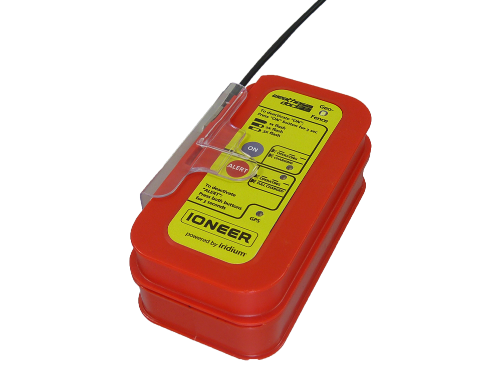
The IONEER-I is a portable transmitter for locating vessels or other objects, offering 24/7 visibility. The device features an integrated bi-directional Iridium® satellite communication module, enabling ‘ship-to-satellite-to-shore’ communication in both directions.
A dedicated ‘push to alert’ button and the ability to record waypoints are just some of the IONEER-I’s outstanding features.
- Product description
- Technical data
- Highlights
- Safety instructions (GPSR)
- Manufacturer information (GPSR)
The new IONEER-I positioning transmitter features an integrated bi-directional iridium® communications module, enabling unlimited, 24/7 visibility. The IONEER-I is designed for continuous location and monitoring of vessels or other moving objects in all areas using VHF technology. The palm-sized position transmitter operates reliably with Class B CSTDMA (Carrier Sense Time Division Multiple Access) functionality and the iridium® satellite network.
Function
The IONEER-I is designed for a wide range of applications, including continuous position reporting and tracking via VHF and/or Iridium®, bidirectional communication within the Iridium® network, or functioning as an Iridium® bridge for mobile devices connected to the IONEER via Bluetooth® LE to communicate with the Iridium® network.
Position reporting and tracking can be transmitted on regular or customized VHF frequencies to an onshore receiving station, such as a fishing fleet headquarters for monitoring fleet vessels. The same position report can also be forwarded to a server-specific IP address via the Iridium® satellite network. Depending on the distance from land, it is possible to switch from VFH-based reporting to Iridium®-based reporting. If VFH communication is not possible, the IONEER-I automatically switches to Iridium® reporting as preprogrammed.
Bidirectional, two-way communication via the Iridium® satellite network allows for extensive radio communication and parameterization. In addition to the position report, additional data and/or the status quo can be read and transmitted.
The IONEER-I is compact and robust and offers a very long battery life of 200 hours for position reporting (within a 5-minute transmission interval). Including Iridium® network communication in parallel mode, the battery life is approximately 24 hours.
Seawater, oil, UV light, and shock resistance round out the IONEER’s high-quality performance.
Characteristics
Custom Broadcast
The terrestrial VFH transmission range can be predefined via software. Once a preprogrammed distance from the coast is exceeded, the IONEER-I automatically switches to the Iridium® satellite network for satellite communication.
Bidirectional Iridium® satellite communication
Communication and parameterization via radio can be bidirectional: ‘ship-to-sat-to-shore’ and vice versa.
Additional “Push-to-Alert” button
Pressing the alarm button transmits a standardized maritime distress message in addition to the regular position report to reach every vessel in the immediate vicinity. Optionally, it is possible to simultaneously transmit a DSC distress call in an ‘open loop’ (all ships call) to the GMDSS rescue chain.
“Who & Where” for Coastal Security and Fleet Management
For national authorities, tracking and identifying vessels within their own territory is becoming increasingly important in coastal protection and security. The scope of possible actions ranges from differentiating between “friend and foe” to monitoring suspicious behavior of cargo ships in coastal areas.
GEO-Fencing
The IONEER-I programming software allows you to create zones that are prohibited from entering or leaving. This allows for the best possible monitoring and documentation of fleet vessels.
Bluetooth Functionality
Using the Bluetooth® LE connectivity of your smartphone or other mobile device, you can display the vessel’s status quo as key figures, such as engine temperature, fuel level, and other important data such as daily fishing reports. The IONEER-I’s optional specialized software and possible companion apps ensure virtually unlimited usage.
Intelligent tamper protection
If the device is stolen or tampered with, a special information message is sent to the receiving station on land and via Iridium® to the dedicated IP server address.
Forward data storage
The IONEER is capable of storing the position data of up to 7,000 waypoints. This data can be read out via software and also displayed on Google Earth®. This ensures optimal transparency in accordance with the IUU guidelines against illegal fishing.
Customization
The IONEER-I can be further customized by programming additional data, such as vessel name, vessel type, and area of operation.
Various power supply solutions
- Charging station
Intelligent charging of Li-ion batteries with a dedicated charging station (easyCHARGER A121). Battery life depends on the preset transfer interval. - Marine generator or battery
Intelligent charging with a fixed solution by connecting to a 9-32 VDC marine engine. - Solar panel
Intelligent charging with a constant external power supply. Also suitable for small artisanal fishing vessels without a power supply.
General specifications
- Dimensions: 130mm (L) x 70mm (W) x 30mm (H)
- Weight: 380 grams
- Protection class: IP67
- Shock resistanceMechanischer Schock
- Impact from a height of 20 meters onto the water surface
- Impact from a height of 1 meter onto a concrete surface
- Thermal shock
- 45K
- Resistance to
- Oil
- Saltwater
- UV radiation (extreme sunlight)
Power supply
- Rechargeable Li-ion batteries
- Power supply possible via
- Charging station (available separately)
- Onboard motor with 9-32 VDC
- Solar panel
- Battery life
- In alarm mode, at least 36 hours (with fully charged batteries)
- In regular mode, 100-180 hours, depending on the set transmission interval (with fully charged batteries)
Environmental specifications
- Operating temperature range: -10°C to +55°C
- Storage temperature range: -30°C to +70°C
- Battery charging temperature range: 0°C to +45°C
Communication
- VHF-based AIS communication
- Iridium® satellite network (bidirectional)
- Bluetooth® LE connection to an app up to 20 meters away
- 72-channel GNSS (Global Navigation Satellite System) receiver for GPS, GLONASS, and Galileo
- Real-time tracking and alerting
- Reliable position reports available 24/7
- Unrestricted visibility of objects
- Bidirectional satellite communication in addition to VHF communication
- Additional ‘Push-to-Alert’ button
- Data recording of traveled waypoints
- Geo-fencing
- Over-the-air configuration

- Please keep the device out of the reach of children!
- The internal, powerful transmitter can potentially harm medical devices such as. B. Pacemakers may be impaired in their function!
- Incorrectly triggering an AIS/DSC emergency call is not a minor offense and can result in subsequent costs!
- Maintenance should only be carried out by authorized service providers/specialist dealers!
- Opening the device without authorization will void the warranty. Unauthorized or violent opening can destroy the device.
- Caution: There is a risk of explosion if the batteries are replaced with an unsuitable battery type. Dispose of used batteries according to the instructions.
- If the device is used at temperatures below 0°C or above 55°C, the capacity of the batteries will decrease. Keep the device away from heat or hot environments. The batteries inside the easy2-MOB could overheat, possibly even explode or burn and cause damage to the device and the surrounding area!
Weatherdock AG
Emmericher Str. 17
90411 Nuernberg
Germany
info@weatherdock.de
Reviews